
Langues:

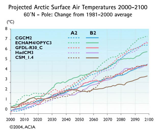
Projected Arctic Surface Air TemperaturesProjected Arctic Surface Air Temperatures 2000-2100 60°N - Pole: Change from 1981-2000 average: The ten lines show air temperatures for the region from 60°N to the pole as projected by each of the five ACIA global climate models using two different emissions scenarios. The projections remain similar through about 2040, showing about a 2°C temperature rise, but then diverge, showing increases from around 4° to over 7°C by 2100. The full range of models and scenarios reviewed by the IPCC cover a wider range of possible futures. Those used in this assessment fall roughly in the middle of this range, and thus represent neither best- nor worst-case scenarios.  Source : ACIA Impacts of a Warming Arctic: Arctic Climate Impact Assessment Publication apparentée :
Other Figures & Tables on this publication : Observed Arctic Temperature, 1900 to Present Observed sea ice September 1979 and September 2003 Projected Vegetation, 2090-2100 Arctic Thermohaline Circulation Projected Arctic Surface Air Temperatures Projected opening of northern navigation routes Factors influencing UV at the surface 1000 years of changes in carbon emissions Projected Surface Air Temperature change 1990-2090 |