
Languages:
The source document for this Digest states:
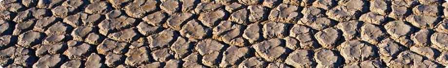
Erroneous plowing techniques can often cause serious erosion
Source: MAUnderstanding the significance of desertification is constrained by many uncertainties. Information gathering— long-term remote sensing and sub-national biophysical and socioeconomic data—enables development of a baseline and indicators of desertification. Such information helps us reduce uncertainties regarding the relationships among desertification, climate change, biodiversity, ecosystem services, and human well-being.
Monitoring, Baseline Development, and Assessment
Without a scientifically robust and consistent baseline of desertification, identifying priorities and monitoring the consequences of actions are seriously constrained.Three assessments of the global extent of land degradation give different figures: the UNEP/GLASOD report (1990), research work from Dregne and Chou in 1992, and a more recent assessment prepared for the MA by Lepers et al. in 2003 (C22.4.1). These assessments of land degradation all have major weaknesses. GLASOD was based on expert opinion only, with variability in quality and quantification. Dregne and Chou’s assessment was based on secondary sources, which they qualified as follows: “The information base upon which the estimates in this report were made is poor. Anecdotal accounts, research reports, travelers’ descriptions, personal opinions, and local experience provided most of the evidence for the various estimates.” The most recent assessment by Lepers et al. has the benefit of combining multiple sources of information but it did not have complete spatial coverage and was limited to 62% of drylands, with some areas relying on a single data set. That assessment was qualified as “an exercise of compilation of data from a variety of sources, with different scales, legends, definitions, etc. We have done our best to standardize but, still, there are many inconsistencies and gaps.” The shortcomings of these available assessments point to the need for a systematic global monitoring program, leading to development of a scientifically credible, consistent baseline of the state of desertification (C22.4.1).
Integrated use of satellite-based remote sensing or aerial photographs with ground-based observations can provide consistent, repeatable, cost-effective data on vegetation cover. Drylands lend themselves readily to remote sensing because they are mostly cloud-free and hence a wide range of images are available. Continuity of observations is required to account for the high interannual variability of dryland ecosystem services. Valid interpretation of remote sensing imagery for desertification requires careful calibration and validation against ground measurements (such as vegetation cover, biological productivity, evapotranspiration, soil fertility, and compaction and erosion rates). Access to affordable satellite imagery, particularly in developing countries, is critical for effectively undertaking such integrated uses (S7.3.3).
Long-term monitoring is needed to distinguish between the role of human actions and climate variability in vegetation productivity. Impacts of human activities (such as overgrazing or soil salinization) and climatic variables (such as interannual variability in rainfall and drought events) on vegetation productivity are difficult to distinguish. One example of this is the repeated droughts and famine in the Sahel region. (See Box 7.1) Quantifying such impacts requires an established baseline of vegetation productivity against which changes can be assessed. Such a baseline is often not available and is further complicated by year-to-year and even decade-to-decade fluctuations (C2.2.1).
Understanding the impacts of desertification on human well-being requires that we improve our knowledge of the interactions between socioeconomic factors and ecosystem conditions.The combination of factors affecting human well-being varies by location and aspect, as demonstrated by the example in Box 7.1 Health outcomes, for example, are the combined result of ecosystem condition, access to health care, economic status, and many other factors. A small increase in food prices resulting from lower yields will affect the well-being of many people. Tracing such impacts is often difficult, particularly in macro-scale analyses where the impacts of ecosystem change are often hidden by aggregation of data or hampered by lack of information. Analyses linking well-being and ecosystem condition are most easily carried out at a local scale, where the linkages can be most clearly identified (C2.ES).
It follows that the gathering of information about socioeconomic factors related to desertification needs to be carried out at sub-national levels.The MA was able to gain specific insights into the correlation of human well-being to the level of aridity by disaggregating economic and well-being data like GNP per person, infant mortality, and the hunger rate in children under the age of five at the sub-national level. This enabled the categorization of these data according to the degree of aridity. National monitoring efforts that directly collect sub-national and perhaps household-level data are essential to our understanding of the impacts of desertification on human well-being (C22.6.1).
Source & ©: MA ![]()
Chapter 7, p.19-21
The source document for this Digest states:
Reducing Uncertainty
There are considerable scientific challenges in detecting thresholds beyond which drylands systems would reach a critical or effectively irreversible change. This partly stems from our lack of understanding about the interactions between biophysical, social, and economic factors. Ecosystem conditions and factors affecting them are dynamic and change over time. This complicates accurate predictions of policy outcomes and detection of irreversible thresholds (C22.6).
The impact of poverty reduction strategies on ecosystem services and desertification has not been fully explored by governments and the international community. More information is needed to assess the linkages between the policies for poverty reduction and combating desertification. Poverty-ecosystem links are typically ignored in poverty reduction policies. Even when these links are included, only the economic values are considered. Successful responses should include broader notions of poverty and should try to mainstream the role of ecosystem services in the main poverty reduction programs.
The contribution of dryland urban areas to desertification may be significant but is not known. Figure 7.1 shows the overlap of urban areas with the four dryland categories. The dependence of these cities on ecosystem services from drylands versus non-drylands is generally not well known. Understanding this dependence will also help determine the degree to which cities may relieve pressure on desertified areas through economic opportunities (C22.4.4).
Source & ©: MA ![]()
Chapter 7, p.21


This summary is free and ad-free, as is all of our content. You can help us remain free and independant as well as to develop new ways to communicate science by becoming a Patron!


